New Buildings on Vacant Lots
Study Site 02 Description
Study Site 02 is bounded by Rockdale Avenue to the north, the confluence of Interstate 75 and Victory Parkway to the east, Blair Avenue to the south, and Reading Road (soon to be renamed President Barack Obama Avenue). The area has a relatively new five-story apartment building and another that houses the Greater Cincinnati Urban League, both located along Reading Road. It is also home to several one- and two-family houses—many three stories high with large porches—and a plethora of vacant lots, some extremely long and narrow due to the area’s irregular orthogonal street grid.
Visual Description
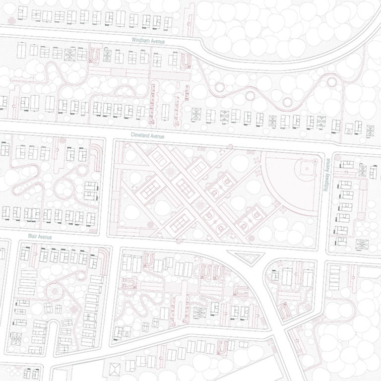
A two-dimensional map shows an aerial view of a residential area. The image is focused around a large rectangular park in the middle. The park is a light maroon color and stands out amongst the black lines of the houses, trees, and streets. The park has a baseball diamond fitting into its top right corner, and tennis and basketball courts are arranged throughout the rest of the park and are connected by linear paths. The park is surrounded by roads and residential streets on all sides. Above the park is Cleveland Avenue which runs from the left to right side of the image. Houses run along the street and face the park. Behind the houses is a wooded area, and another road, Windham Avenue, which runs parallel to Cleveland Avenue, with houses lining each side. The houses along Windham Avenue and Cleveland Avenue are interconnected through paths curving through the trees which are marked by light maroon lines. Running along the bottom edge of the central park is Blair Avenue with houses on other side of the road on the left side of the street. Across from the park on the other side of Blair Avenue are a mix of public and residential buildings, also connected to each other through curvilinear paths. Some houses are interspersed as well. A road branches off of Blair Avenue and turns towards the bottom of the frame and continues out of view.
Distinguishing Features
- Blair Avenue. Prior to highway construction, it connected Reading Road to Walnut Hills via Beresford Avenue. While this connection still exists, it occurs via an unsavory bridge over the highway. The area underneath the bridge has been taken over by large warehouses, creating a blighted condition in the southernmost portion of the site.
- Continuing north, Blair Avenue borders a public property that once contained a community center and swimming pool that were off limits to African American children, who were forced to watch white children at play through a tall cyclone fence. Today, the building and pool have been demolished and the fence has been lowered. What remains is a grassy field with tennis courts, basketball courts, baseball fields, a child’s playground, and a parking lot. This underutilized, centrally located property has the potential to connect residents and offset the degradation to the south.
- Windham Avenue, which winds down from Reading Road through Woodward Park to Rockdale Avenue and onto Victory Parkway. This area could either be a threat to safety or a place for residents to become actively engaged in the maintenance of the park.
Visual Description
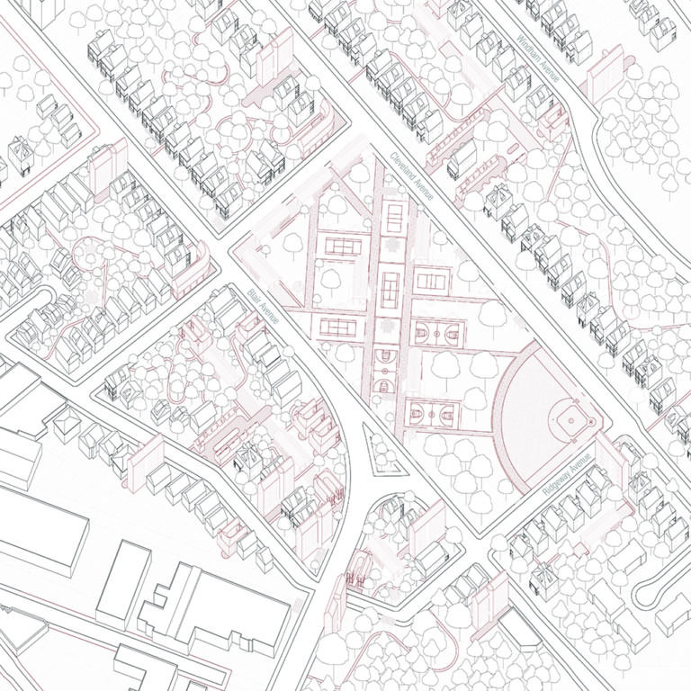
A slightly three-dimensional map is focused on a park that is bordered by Cleveland Avenue and Blair Avenue. The park is a light maroon color and stands out amongst the black lines of the houses, trees, and streets. The park has a baseball diamond fitting into its top right corner, and tennis and basketball courts are arranged throughout the rest of the park and are connected by linear paths. The park is surrounded by roads and residential streets on all sides. Across from the park on the Cleveland Avenue side is a row of two- or three-story residential buildings that all face Cleveland Avenue. There is empty space behind the houses that is filled with trees and light maroon paths that connect Cleveland Avenue to the parallel Windham Avenue, which also has houses lining it. On the Blair Avenue side of the park, across the street are two- or three-story buildings interspersed with public buildings and curving paths that connect the structures together through wooded areas. Moving up Blair Avenue towards the map’s top left corner, more houses in a row face the street. On the right side of the park, where the baseball diamond is, runs Ridgeway Avenue, which connects Cleveland and Blair, as well as creating an intersection with the road that branches of Blair Avenue and moves towards the bottom of the frame. Along this road are more houses and trees.
Objectives
In Study Site 01, the Decolonizing Suburbia team explores strategies for the development of new buildings on vacant lots to achieve the following:
- Connect residents through mixed-use public spaces. The public playfields at the center of the site can replaced with Long Houses that provide small-scale residential and commercial spaces that are interspersed with small-scale recreation spaces, leaving room for a single ballfield at one corner of the property. Long Houses will provide private space to live and work, while increasing the number of “eyes” on new semi-public play areas.
- Increase safety through collective ownership. Woodward Park, currently a space to drive through, has the potential to become a cherished ecological amenity, a bioswale cared for by a Friends of the Park-style organization where children from the nearby elementary school can learn about rainwater catchment and storage. To encourage such collective ownership, the team has placed a new five-story Tall House at the head of the park where the Friends can have offices and programmatic spaces.
- Create corner buildings with commercial spaces.
- Add housing density, especially toward the south of the site.
Avondale Community Council Goals
- Increasing Safety
- Connecting Residents
- Improving Housing
Legal and Policy Considerations
These interventions, which strategically meet the street, would necessitate changes to existing zoning laws that require front yards.
Toolkit Interventions
Long House
Long House responds to a common condition in Avondale: the extremely long, narrow lot. Rather than positioning a squarish house in the center of a property, Long House positions a long, narrow, single-story structure containing three to four dwellings on one side of the lot, allowing the remaining area to become shared outdoor space. On the street side, Long House widens to provide space for a commercial storefront. If two adjacent long lots are available, the Long House can be mirrored to create a central courtyard that is entered through a gateway of shops. By arranging small dwellings collectively, the Long House provides an alternative housing option for Avondale’s considerable population of young singles.
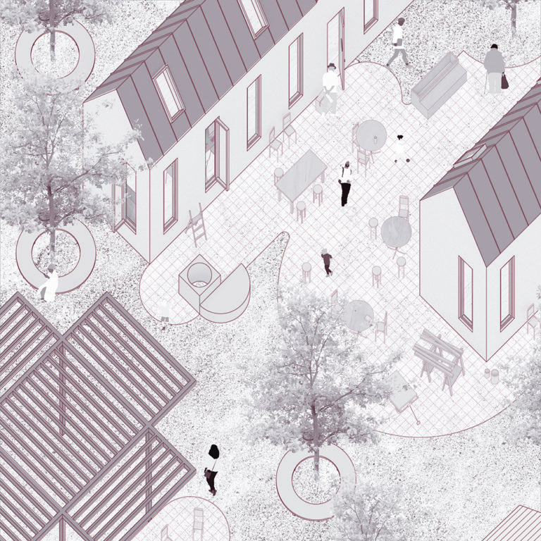
Visual Description
A 3-dimensional illustration of rectangular houses that stand on either side of a paved common space, distinguished from the surrounding grassy areas by a grid pattern. The paved area has tables with seating and people moving around the space. On the left side of the paved area is a structure with tall rectangular windows. The building runs across the upper left section of the frame and continues towards the top right out of view. On the opposite side of the paved common space is a second building, but only the short side of the building is visible. Both have simplistic gable roofs with windows inserted into them. In the bottom left corner is a pergola made of slatted beams. Between the paved area and the pergola are trees that stand in circular planters.
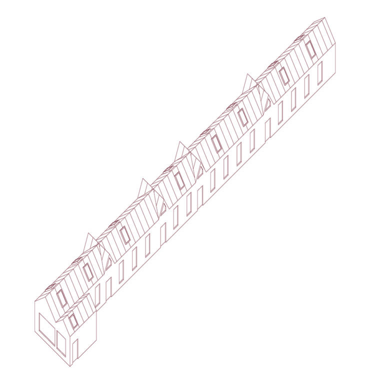
Visual Description
A linear illustration from an aerial view shows a 3-D rendering of a long skinny residential structure. It extends from bottom left corner to top right corner. The short end of the house in the bottom left corner and the long side of the structure on the right are visible. The back of structure and short end on the top right corner are not visible. Rectangular windows line the long end of the house, with doors placed every three or four windows. On the sides of the roof, rectangular windows are placed as skylights.
Corner House
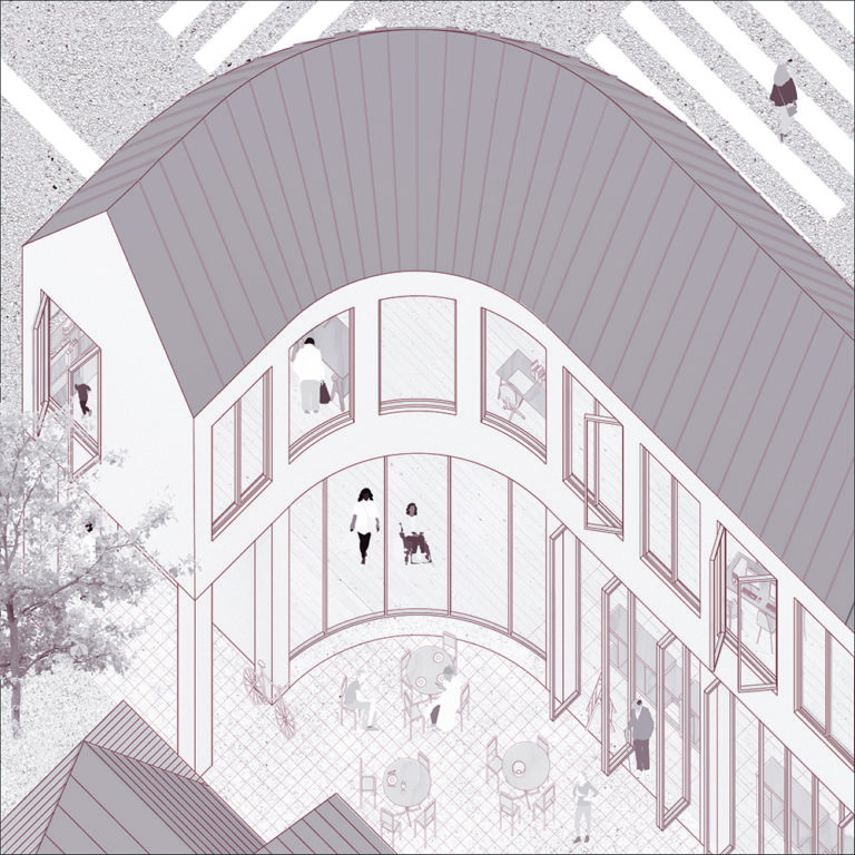
Corner House responds to the vacuous condition that is created when a standard rectangular building ends at a corner. Current yard regulations result in the long side of these corner lots being occupied by the often-blank sides of single houses. Corner House lofts one or two dwellings above a large storefront space that faces both streets. This ground-floor, street-fronting space can accommodate a small grocery store, which is sorely needed in the Avondale food desert. Corner House’s massing creates an opportunity for a shared rear courtyard and the rounded corner condition allows for a street-front patio for use by the ground-floor tenants.
Visual Description
A three-dimensional rendering of a two-story structure depicts its unique curvilinear shape. The rectangular building comes into the frame on the right side, where it continues out of view. Moving towards the left, the building reaches a street corner and instead of ending, it curves to the left, encompassing the entire street corner. The tall structure blocks a view of the sidewalk, but a crosswalk extends from the right and left sides of the corner of the roof, showing that it is a street corner that the structure is curving around. The building ends at the left edge of the frame. The top story of the curved structure has large rectangular windows – some of them are open and inside we can see desks and people. On the bottom story, there is a large wall of windows at the curve of the building with two people visible through them. To the right of the windows are large, tall doors that are open onto a courtyard. The courtyard has tables, seating, and people. On the bottom floor to the left of the curved windows is an overhang from the second story which provides a covered walkway from the courtyard to the street.
Visual Description
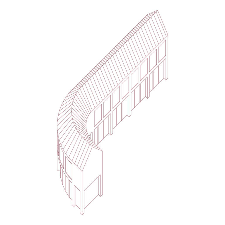
A three-dimensional linear rendering of a tall skinny building that is straight on the right end and at the left end curves to the right. A gable roof covers the structure. The curve allows us to see two windows that are on the left side of the building, but the rest of it is out of view. The right side of the building has large square windows lining the top-story and large rectangular glass doors that can also act as windows on the bottom story. The focus of the building is its curve.
Tall House
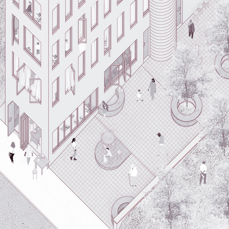
Tall House is a narrow, five-story building set to one side of a standard Avondale lot. As much a landscape as an architectural intervention, it responds to the common Avondale condition of a steep grade change between the sidewalk and the lot. The Tall House smooths that grade change with a lot-width ramp that leads to a platform of shared outdoor space. The ground level of the building features a street-facing storefront, with community space accessible from the platform, the ramp, or both.
Visual Description
An illustration offers a slightly aerial view of tall building with a courtyard and adjacent park is seen as if the viewer is in a top floor of a tall building across the street. The building, courtyard, and park all run parallel to each other, and people are moving throughout each space. The building is on the left side of the frame. Four floors of the building are visible, each with large windows, some of which are open. Inside, people and desks are visible. To the right of the building is the paved courtyard, signified by a grid pattern. The courtyard runs along the length of the building and has semi-circular benches, tables with seating, circular tree planters, and a low incline ramp leading from the street into the courtyard. To the right of the courtyard is a grassy area, where a person walks through the natural ground and is surrounded by small trees.
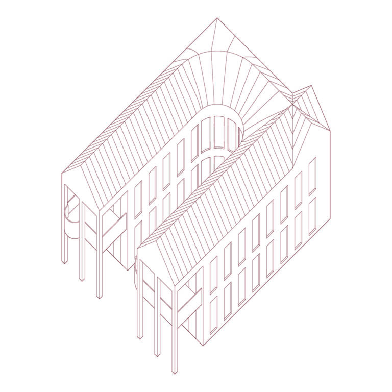
Visual Description
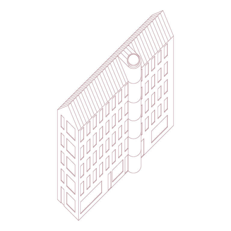
Three-dimensional linear illustration of a tall, narrow, five-story building. The front of the building is the short end and has large square and rectangular windows on each floor. The entry door is on the bottom floor and faces the bottom left corner. Along the right side of the building are rows of rectangular windows along each floor. Each floor has 13 vertical windows, except for the bottom floor which has three horizontal rectangular windows alternating with doors. In about the middle of the long right-side wall is a cylindrical component to the building that runs from the bottom floor all the way to the gable roof.
Double-Porch House
Double-Porch House is designed to occupy a traditional suburban lot measuring approximately 50 feet by 100 feet. The intervention leverages the use of a widespread vernacular element in Avondale: the porch. With room for four dwellings, the design pushes the building mass to either side of the lot to create a central shared courtyard that opens towards the street, flanked by two-story porches on either side, meaning that each dwelling gets a front porch. An optional street-fronting kiosk creates spatial closure to the central courtyard while providing an opportunity for commercial activity.
Visual Description
A two-story structure has a semi-oval shape. The structure is one unit. Two symmetrical rectangular buildings run parallel and are conjoined at their back ends by curving towards each other. The curve creates a courtyard in the middle and windows face the other building. The left side of the building has two separate facades – both have porches that overhang the entrance. The building has two separate entrances which enter separate residential units, but they are combined at the back.
Reference
Henry Louis Taylor, Jr., Race and the City: Work, Community, and Protest in Cincinnati, 1820–1970, Chicago: IL, University of Illinois Press, 1993.