Additions to Lots with Existing Buildings

Study Site 04 Description
Study Site 04 is bounded by Glenwood Avenue and the southern arc of Fred Shuttlesworth Circle to the north, Reading Road to the east, Glenwood Avenue to the south, and Washington Avenue to the west. An area that was home to a solidly middle-class Jewish population even after the southern portion of Avondale had become a segregated African American neighborhood, it has many single-family residences—some quite large and others more modest—that remain from an earlier era of grandeur.
Visual Description
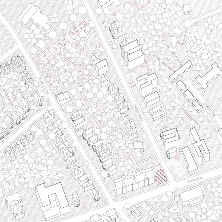
An aerial view of a map has avenues in white, structures outlined in black along the roads, and public spaces in maroon. Two avenues, Gholson and Glenwood, run from the left side of the frame to the right at a slight downturned angle. They reach Reading Road at a perpendicular angle. Along Gholson Avenue on the north side, from left to right, are rectangular structures and then a windy path through trees connecting to a cul-de-sac that extends out of the frame. To the right of the windy path is more structures, and a triangular park, and then more structures that border both Gholson Avenue and Reading Road. Up the road of Reading is Chalfonte Place, a cul-de-sac with rectangular structures that borders the windy path. Parallel to Gholson Avenue is Glenwood Avenue. The two are connected on the leftmost part of the streets in the frame by a series of athletic courts that connect the roads. Between Gholson and Glenwood are rectangular structures that line each street and a series of stairs that run in between the houses. Bordering Glenwood Avenue and Reading Road is a large rectangular building. On the southern side of Glenwood Avenue is more rectangular structures, a windy path, and a road that extends to the bottom of the frame and continues out of view. Most empty space has circles that symbolize trees.
Distinguishing Features
- A large swath of undeveloped property, located between the Glenwood/Shuttlesworth northern boundary and Gholsom Avenue, is penetrated by three cul-de-sacs, church parking lots, and apartment buildings that front the main streets. A similar, smaller undeveloped area exists between Gholson Avenue and Glenwood Avenue.
- The prevalence of surface parking lots connected to religious institutions, including New Evergreen Missionary Baptist Church, the recently enlarged Zion Baptist Church, Rose Chapel Missionary Baptist Church, and Cincinnati Shiloh Seventh-Day Adventist Church. These institutions now serve congregants who drive in from distant suburbs, leaving areas of asphalt, several occupying corner lots, largely unused on weekdays. In combination with the vacant lots where buildings have been demolished, these seas of macadam contribute to the site’s comparatively low population density.
- The huge variability of housing stock, which ranges from well-maintained and beautifully landscaped mansion-like homes to older homes that are dangerously deteriorated and cheaply constructed multi-unit residences.
Visual Description
An aerial from of a slightly three-dimensional map shows Gholson and Glenwood Avenue which run from the top of the frame towards the bottom. Running along the bottom of the frame is Reading Road. Glenwood and Gholson Avenue are connected to each other at the top of the frame by maroon athletic courts with a walking path extending off of it into trees. Gholson Avenue is lined by tall buildings on the right, and a windy path connects Gholson to a cul-de-sac that extends into the frame from the top right corner. Beneath this cul-de-sac is another cul-de-sac labeled Chalfonte place, which runs parallel to Gholson. In between the two is a triangular park with trees. The intersection of Reading Road and Gholson has various tall structures. Glenwood Avenue is lined with smaller residential structures with a winding path extending off Glenwood Avenue to the left side of the frame. Two streets extend off of Glenwood avenue and continue out of view to the left side of the frame.
Objectives
In this site, the Decolonizing Suburbia team explores strategies make additions to lots with existing buildings to achieve the following:
- Create a natural drainage system in underutilized property. Because many large parking lots border this property, it offers an ideal opportunity to capture runoff that would otherwise overload the city sewer system during climate events.
- Activate the landlocked property with spaces for education and entrepreneurship.
Within the beauty created by the natural drainage system, neighborhood youth can study ecology hands-on while adults grow and market produce.
Celebrate Avondale’s history as an electric streetcar suburb. - Local artists can create public art installations at bus stops to counteract the neighborhood’s pervasive car culture and celebrate its history of public transit.
Avondale Community Council Goals
- Increasing Safety
- Sharing Success
- Connecting Residents
Supporting Policies
The heavy lift for these interventions involves changing the zoning laws so that the landlocked property can be developed with an accessible natural drainage system and related educational and entrepreneurial spaces.
Toolkit Interventions
Parking Lot Activation
This tool activates church parking lots that sit vacant during the week via flexible platforms that support community-oriented activities. Because these large lots already have broad, accessible ramps for cars, they can easily be transformed into temporary, universally accessible public spaces for anything from cookouts to community meetings to public performances. These flexible platforms, which can be designed and installed by local artists, also provide storage for the equipment (tents, seating, and signage) necessary to turn a sea of asphalt into an active community space. These temporary activation platforms could serve as a first step toward convincing religious institutions to further develop their properties to meet community needs.
This tool activates church parking lots that sit vacant during the week via flexible platforms that support community-oriented activities. Because these large lots already have broad, accessible ramps for cars, they can easily be transformed into temporary, universally accessible public spaces for anything from cookouts to community meetings to public performances. These flexible platforms, which can be designed and installed by local artists, also provide storage for the equipment (tents, seating, and signage) necessary to turn a sea of asphalt into an active community space. These temporary activation platforms could serve as a first step toward convincing religious institutions to further develop their properties to meet community needs.
Visual Description
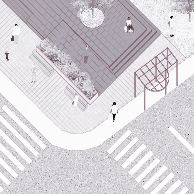
An aerial view of a street corner and intersection shows a public space made of stone, marked by grid patterns. Crosswalk lines extend from the bottom left and bottom right to the sidewalk and public space. The left side of the space has benches with their backs to a planter that face the crosswalk. Behind the planter is a ramp with a person with a cane walking on it. The ramp leads to an elevated section of the space, which is also accessible by stairs. There is a tree on the elevated space. People are seen walking on the sidewalk, sitting on benches, and walking on both levels of the space. The sidewalk has a pergola structure on the right side of the space.
Visual Description
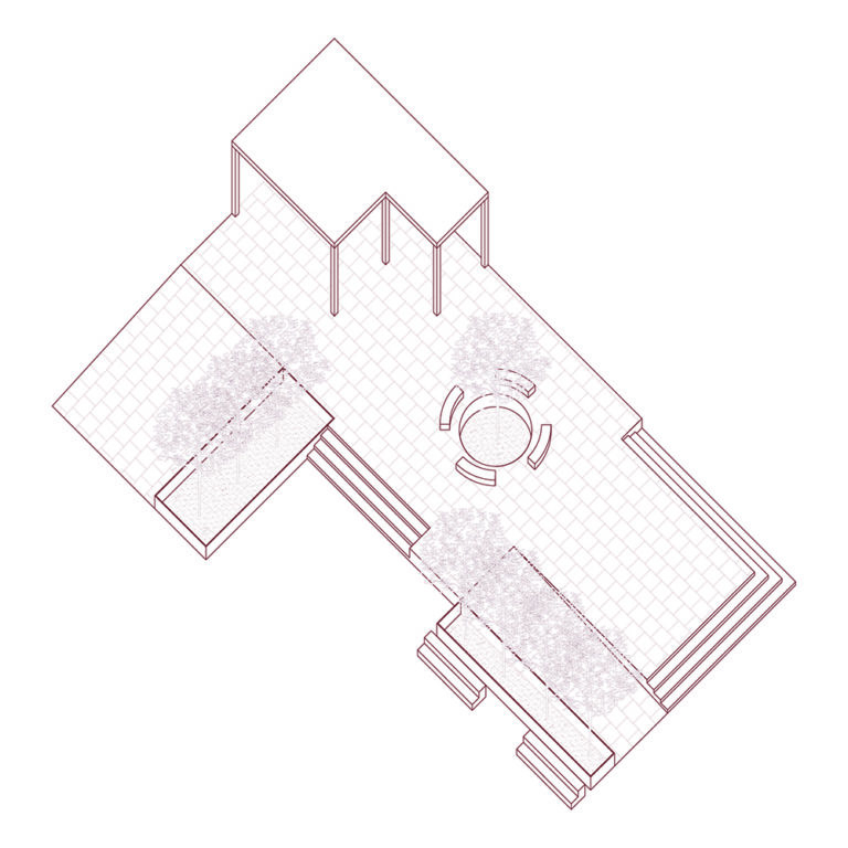
A linear illustration of an elevated platform is made of stone, which is marked by a grid-pattern. On the right of the platform are stairs and a ramp, which is bordered by a planter with benches resting against it. Moving onto the platform from the right side, there is a tree encircled by benches, with more stairs to access the space on the left. Beyond the tree is a corner that is covered by a structure that is a roof with no walls. To the left of the cover is a wide ramp which is bordered by a planter.
Ecological Education
Circular seating areas located along the new natural drainage system form a series of outdoor classrooms where small groups of students can study hands-on the site’s unique ecology. Bioswales planted with a combination of ornamental grasses, shrubs, and perennials would create a habitat for bees, birds, butterflies, and other insects, providing a delightful sensory space for students to develop the values and skills needed to become environmental stewards. These simple structures and related planted areas can be constructed by novice builders.

Visual Description
An aerial view of an illustration of two athletic courts that are surrounded by stone walkways. A basketball court extends into the frame from the top right corner. A tennis court, surrounded by a fence, extends into the frame from the bottom left corner. The two have stone walkways on all sides. In between the two courts, the walkways have benches facing the courts. The benches are placed along a grassy area with a pergola and a tree. People are walking on the paths and on the courts.

Visual Description
An illustration of maroon trees and planters on a white background. There are six circular planters that float in the background of various sizes, each with trees in them. One planter is very small with enough space for only one tree. Two planters are medium sized, each with one trees in them. Three of the planters are large and hold two trees. Two trees in the illustration are not in planters. The planters are elevated platforms that someone would be able to sit on.
Public Transit Activation
Using a similar formal language as the planted pergolas that populate Site 03, these public transit activations bring public art to key bus stops along Reading Road to encourage the expansion of Cincinnati’s public transit system to include east-west routes into the interior portions of Avondale. These public art pergolas would provide transit users with shelter and other amenities while reconnecting the neighborhood to its history as a vibrant streetcar suburb.
Visual Description
An aerial view of a street corner and intersection shows a public space made of stone, marked by grid patterns. Crosswalk lines extend from the bottom left and bottom right to the sidewalk and public space. The left side of the space has benches with their backs to a planter that face the crosswalk. Behind the planter is a ramp with a person with a cane walking on it. The ramp leads to an elevated section of the space, which is also accessible by stairs. There is a tree on the elevated space. People are seen walking on the sidewalk, sitting on benches, and walking on both levels of the space. The sidewalk has a pergola structure on the right side of the space.

Visual Description
A linear illustration has a bus on the left and a covered pergola on the right. The bus has two sets of doors and white rectangular windows along the side. The pergola is polygonal in shape with lines creating a grid roof that has slightly opaque maroon coloring in the squares, showing the roof is covered.
Farmers Market and Greenhouse
These small pop-up structures provide opportunities for farmers to market their produce on undeveloped property. Located along a universally accessible circulation system created by the new natural drainage system, the structures are light and can be easily deployed. Some structures have an overhanging roof that provides shade around the market space; others have a slanted, glazed roof that creates a gabled greenhouse for wintertime growing. These simple structures can be built by novice builders.
Visual Description
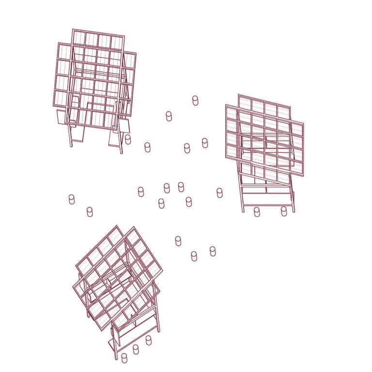
Illustrations of three structures are set against a white background. There is one on the top left, one on the bottom left, and another on the right side in the middle of the frame. They are all the same structure facing different angles. The structures are open-air with glass roofs. The roofs are set on an angle that covers the interior and overhangs, providing shade for people who may stand around it. Inside the structures are U-shaped shelves. There are no solid walls, allowing for light and air to move through the structures. Small cylinders are scattered around the structures and in the space in between them.